图片名称

Drone Detection, Countermeasure, And Anti-interference Solution

全部
  • 全部
  • 产品管理
  • 新闻资讯
  • 企业视频
  • 企业图册
undefined
Fixed spoofing
Fixed spoofing
video
正面1(1744854042845).jpg
右侧面(1744854043188).jpg
左侧面1.jpg
正面(1744854043181).jpg
蘑菇头.jpg
细节(1744854042851).jpg
细节2.jpg

Fixed spoofing

Category:

Key Words:

Fixed spoofing

fixed-position drone spoofing and jamming unit

  • Product Detail
  • parameter
  • DataTheoryNavigation deception jamming
    Coverage360°whole airspace
    Working Frequency 10 bandsGPSL1 1575.42MHz
    GPS L2 1227.6MHz
    BDS B1 1561.098MHz
    BDS B2 1207.14MHz
    Glonass L1 1602MHz
    Glonass L2 1246MHz
    Galileo 1575.42MHz
    GPS L51176.45MHz
    Galileo E5A1176.45MHz
    QZSS L1 1176.45MHz
    Power Output≤10mW to 20W (depends on requirements)
    Reaction Time<10.0s

    Simultaneous

    Deception Quantity

    ≮10 drones
    Frequency Tolerance≤±2×10⁻⁶
    Spoofing SystemPackingMainhost Size410mm×190mm×335mm(LWH)
    Mainhost Weight≤20kg

    Charscteristic

    > Equipped with comprehensive defense and multi target drone deception capabilities.
    > Milliwatt level signal power, with little impact on the surrounding environment.
    > Capable of interfering with the navigation components of the Black Flying Drone.
    > Multiple  defense  devices  support  joint  deployment  through  networking  for  easy  management  and
    control.
    > No need for manual duty, capable of 24-hour automatic defense against drone intrusion.
    > Various low altitude security scenarios such as State Grid Electric Power, Petroleum and Petrochemical,government agencies, public security and border defense.


    The drone navigation deception device uses advanced satellite navigation simulation technology to generate launch navigation deception signals, enabling the drone to land in place,
    Drive away the drone or guide the drone to land at a designated location.
    By deploying drone navigation and deception devices, a hemispherical control area centered around the device is formed. Drones are unable to operate within the controlled area
    Takeoff, unmanned aerial vehicles outside the control area cannot enter and can counter drone swarms. Can be deployed in a distributed manner across multiple sites, forming a drone control network
    Network, covering a larger control area while facilitating management. It can be used for large-scale event support, as well as for protection in key areas. The device can
    It can be used alone or in conjunction with drone low altitude detection radar and drone detection countermeasures. Can be deployed individually and in vehicles
    Deployment and fixed deployment. The equipment has passed explosion-proof certification and is particularly suitable for special environmental applications such as petroleum and petrochemical.

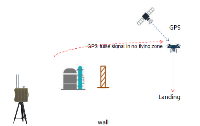
    • Anti interference Module

      • Elements
      • Bands

Applications

Defense and Security

Defense and Security

Protecting critical infrastructure, military installations, and public events from potential drone threats.

Aviation

Aviation

Safeguarding airports and airspace from unauthorized drone incursions that could jeopardize flight safety.

Energy

Energy

Securing power plants, oil refineries, and renewable energy facilities from espionage or sabotage by rogue drones.

Public Safety

Public Safety

Enhancing the safety of large public gatherings, such as sports events and concerts, by preventing disruptive or dangerous drone activities.

Commercial and Industrial

Commercial and Industrial

Ensuring the security of corporate campuses, industrial sites, and private properties from drone-related risks.

Factory Environment

Cinofiber will continue to be a leader in the optical communication industry, providing customers around the world with more stable, reliable, and high-quality products and services.

Certificate Of Honor

Related Products

70M-10G Unmanned aerial vehicle spectrum detection with offline analysis function

JDF10 Stationary Drone Spectrum Detection System1.General DescriptionThe SD1 drone spectrum detection device can identify common civilian drone models on the market (including video transmission signals and control signals), simultaneously detect over 40 targets, and possesses basic capability for identifying drone operators. The device passively intercepts drone signals, operates 24/7 regardless of weather conditions, emits no high-power electromagnetic radiation, has a detection range exceeding 5 km with a maximum range beyond 10 km. Through a browser, users can view real-time information such as the drone's electronic fingerprint (or SN), target orientation, position, time, frequency, likelihood, model type, and manufacturer. It provides a RESTful API for seamless integration with other systems.CharacteristicsPassive detection: The system employs passive positioning technology, utilizing electromagnetic wave signals transmitted by drones and remote controllers for radiation source localization. This approach does not interfere with existing equipment, ensuring safety and reliability. It possesses early warning capabilities.Full-frequency band broadband monitoring and signal analysis: from 70MHz to 10000MHz full band scanning. It covers various transmission links, reliably ensures the detection of frequency-hopping signals, and features signal recording and analysis capabilities.Local signal analysis and decoding capability: The device requires no internet or peripheral connections and features the following decoding capabilities: offline decryption of DJI drone IDs; ADS-B signal parsing; MAC address decoding via Wi-Fi (including e-Wi-Fi); and video decoding for FM analog transmission.Integration capability: The device supports integration with various types of countermeasures, including omnidirectional interference, directional interference, and deception techniques. Multiple devices can be configured for networking and centralized control management.SpecificationDetection Function & PerformanceContentDetailNotesDetection Frequency Range70MHz to 10GHzDetection Distance7KmMaximum 10 km, with variations depending on the electromagnetic environment and the detection distance of the drone.Direction Finding Accuracy≤10°Detection Coverage360° airspaceSimultaneous Detection Amount ≥40 setsMulti-objective DetectionSpectrum Detection70MHz to 10GHz full bands scanRID DetectionOffline Analysis SupportChina GB42590 -2023, US ASTM F3411-22a, Europe ASD -STAN PrEN4709-002Drone ID DetectionOffline Analysis SupportMavic2、Mavic3、air3s、Matrice4 and so onADSB DetectionSupports ADS-B information analysis for broadcasts from civil aircraft and similar sourcesAnalog video analysis capabilitySupports analog video decoding across the full frequency band from 70 MHz to 10 GHzInstant video imagesOther FunctionsContentDetailNotesLocating FunctionFeatures GPS automatic positioning and north alignment functionUnattended functionAuto mode on, and device will record events and follow setting to operate defence.Networking FunctionMultiple devices can be networked (AOA)Integration CapabilitySupports to integrate with countermeasure means and other detection means (Radar/Camera)Other PerformanceContentDetailNotesPower80 ~ 264V AC 113 ~ 370V DCAverage Power Consumption≤100WWorking Temperature-20°to 60°SizeD350mmⅹH480mm Net Weight15KgSoftware Image

Stationary detection equipment JDF5

Detection bands:433MHz, 800MHz, 900MHz, 1.4GHz, 2.4GHz, 5.2GHz, 5.8GHzSupporting range from  30MHz to 6GHz Passive Detection:It only passively receives and does not transmit any electromagnetic signal, and can detect the UAV model and its electronic fingerprint.Accurate Identification:It can accurately identify different UAVs of the same brand and model.Unmanned:Turn on unattended mode, which can automatically detect alarms 24 hours a day.White and Black List:It can mark the black-and-white list with one key, and the white list UAV does not alarm.Full Drone Library:More than 350 types of model library, supporting DJI full series, mainstream brands and DIY UAVs, covering more than 98% of UAV models on the market.Integrability:Professional UAV detection software, which can be integrated into radar, photoelectric and jamming control systems.  Bands supported30MHz—6GHz full bands detectionKey detection frequency bands:433MHz\900MHz\1.4GHz\2.4GHz\5.2GHz\5.8GHzDetection DistanceRadius 5km, coverage scope 10kmAccuracy ≤3°Hovering         ≤10°MovingSensitivityBetter than -115dBm(25kHz)Directivity360°OmnidirectionalAdaptable Communication Modulation MethodFM, 2FSK, 4FSK, GFSK, MSK, BPSK, QPSK, 16QAM, 64QAM, OFDM, DSSS, FHSSSimultaneous Detection≥50 dronesDetection ModePanoramic scanning, channel scanningDynamic Range70dBPower SupplyAC220V±20V (110V customized)Operating Time7*24HSupporting:  new DJI models  OC2, OC3, OC4 protocol DJI drone:    Mavic 2, Mavic 2 enterprise,   Phantom 4 Enterprise V2, Mavic 3, Mavic 3 Classic, Mavic 3 Enterprise, DJI Mini 2, DJI Mini3. DJI Mini4, Avatar, Avatar 2, Mini 4 Pro, M300, M350 RTK,  some Parrot drones and so on.Functions:  showing real ID of drones, longitude and latitude, height of drones, route tracking, pilot location, and so on.   

Online Inquiry

We will contact you within one working day. Please pay attention to your email.

%{tishi_zhanwei}%